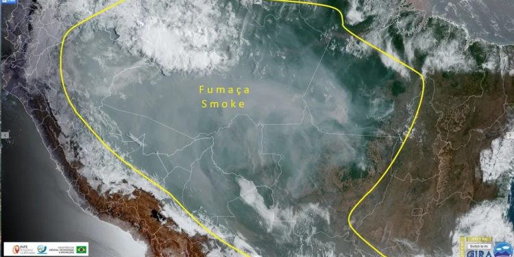
BRAZIL – A “cloud” of smoke caused by forest fires is spreading across northern Brazil and neighboring countries on Monday (5), the date when Amazon Day is celebrated. An image recorded this afternoon by the geostationary satellite Goes-16 shows the following states under the impact of the dispersion of pollutants: Acre, Amazonas, Rondônia, Roraima, Mato Grosso and Pará. According to data from the National Institute for Space Research (INPE), the area covered by the smoke covers five million km².
The destruction accumulated in 2022 in the biome is already worse than that seen last year: from the beginning of the year until Sunday (4), the Amazon had 58 thousand fires, a total that represents 20% more than that registered in the same period of the previous year.
Data that will still be recorded in the historical series shows the situation on Monday afternoon (5): the Aqua satellite detected 2,706 fires, of which 913 (34%) in Amazonas, 725 (27%) in Mato Grosso, 638 (24%) in Rondônia, 227 (8%) in Acre, 197 (7%) in Pará and 6 (0.2%) in Maranhão.
Unlike the images that show the ground situation in almost real time, the data on pollution caused by the smoke takes two days to be consolidated by Inpe. In the most recent one (see above), taken on Saturday (3), it is possible to see a pollution corridor covering the North, Midwest and Southeast of the country. In the image, the smoke appears brown, and the fires are marked with small red crosses.
Burning in Pará
One of the most affected states is Pará, where in just four days 27% more fires were registered than in the whole of September 2021. Last year there were 3,828 fires in the month in Pará. Until Sunday, the 4th, satellites registered 4,889 points of fire in the forest at the beginning of September, according to data from the National Institute for Space Research (Inpe). It is in Pará that a fire has resisted for more than 10 days in Jacareacanga, in the southwest of the state. The fire started in a private area and got out of control, affecting the Wildlife Refuge “Rios São Benedito” and “Azul”, reached the Onçafari and the Raquel Machado Institute, besides causing the evacuation of inns and reaching private areas.

The region affected by the fire is on the border of Pará and Mato Grosso, about 100 km from the city of Paranaita (MT) on the banks of the São Benedito River, in the hydrographic basin of the Teles Pires and Tapajós rivers, and is attractive for ecotourism, sport fishing tourism, besides having conservation units, which attracts researchers.


